English   Română   Español   Français   Deutsch  

getamap.net

Africa

Oceania

Asia

North America

Europe

South America

Antarctica


53°0'0" S
73°18'0" E
~339m asl
( - UTC/GMT+)

Laurens Peninsula (Laurens Peninsula) is a peninsula (class T - Hypsographic) in Heard Island and McDonald Islands (general), Heard Island And Mcdonald Islands [ Australia ] (Antarctica) with the region font code of Americas/Western Europe. It is located at an elevation of 339 meters above sea level.

Its coordinates are 53°0'0" S and 73°18'0" E in DMS (Degrees Minutes Seconds) or -53 and 73.3 (in decimal degrees). Its UTM position is CB82 and its Joint Operation Graphics reference is SN43-01.

Current local time is ; the sun rises at 08:53 and sets at 21:00 local time ( UTC/GMT+). The standard time zone for Laurens Peninsula is UTC/GMT+
In 2024 DST starts on - and ends on -.

A Peninsula is an elongate area of land projecting into a body of water and nearly surrounded by water.


Country
 Advertisements:


 Advertisements:


Weather Laurens Peninsula (Cloud cover, Temperature, Wind speed and Precipitation mm probab.)

Sat


Apr 27
Clound 30-100-100-90 Mist
~3 l/m2 64%
 
3 °C min
5 °C max
64 km/h
Thu Jan 1

Sun


Apr 28
Clound 20-50-50-50 Mist
~8 l/m2 76%
 
1 °C min
4 °C max
41 km/h
Thu Jan 1

Mon


Apr 29
Clound 40-80-90-70 Mist
~15 l/m2 88%
 
3-7 cm (Snow)
0 °C min
3 °C max
75 km/h
Thu Jan 1

Tue


Apr 30
Clound 50-70-80-0 Mist
~9 l/m2 61%
 
3-9 cm (Snow)
0 °C min
2 °C max
74 km/h
Thu Jan 1

Wed


May 1
Clound 40-70-10-0 Mist
~5 l/m2 46%
 
2-5 cm (Snow)
-1 °C min
1 °C max
64 km/h
Thu Jan 1

Thu


May 2
Clound 40-80-50-0 Mist
~4 l/m2 53%
 
2-4 cm (Snow)
-1 °C min
2 °C max
49 km/h
Thu Jan 1

Weather Graph

Laurens Peninsula (Heard Island and McDonald Islands (general)) 7 day forecast
 

Map and Photos Laurens Peninsula


Comments

--- There are no comments yet ---


Add a new comment:


You have to log in to add a comment!


Members area


Register

Forgot password?

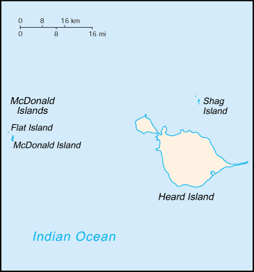
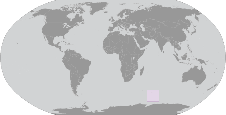
Heard Island And Mcdonald Islands [ Australia ] (Australia):

Advertisement


GPS points near Laurens Peninsula

square Mount Dixon (1 km)

square The Sentinel (2 km)

square Jacka Glacier (2 km)

square Hayter Peak (2 km)

square Mount Olsen (2 km)

square Black Cliff (2 km)

square Black Cliffs (2 km)

square Kap Vanhoffen (2 km)


square Red Island (3 km)

square Sydney Cove (3 km)

square Cape Laurens (3 km)

square Cape Lawrence (3 km)

square Cape Lorenz (3 km)

square Macey Cone (3 km)


GPS points from Heard Island And Mcdonald Islands [ Australia ] (Australia)

square Mount Dixon Heard Island And Mcdonald Islands (general)

square Big Ben Peak Heard Island And Mcdonald Islands (general)

square Abbotsmith Glacier Heard Island And Mcdonald Islands (general)

square Schmidt Glacier Heard Island And Mcdonald Islands (general)

square Jacka Glacier Heard Island And Mcdonald Islands (general)

square Mount Olsen Heard Island And Mcdonald Islands (general)

square Territory Of Heard Island And Mcdonald Islands Heard Island And Mcdonald Islands (general)

square South West Bay Heard Island And Mcdonald Islands (general)


viewweather.com sv.ViewWeather.com
fr.ViewWeather.com
da.ViewWeather.com
de.ViewWeather.com
es.ViewWeather.com
www.carpati.org
www.searchromania.net
Deblocari usi
es.getamap.org
fr.getamap.org
de.getamap.org
nl.getamap.org
da.getamap.org
www.getamap.org
Links
Terms of use
Privacy policy

# 0.0604 sec 

contact AT getamap.net

© 2006 - 2024  https://www.getamap.net/